This
week in Pennsylvania archaeology (TWIPA) has defined many different types of
stone tools found on Pre-Contact archaeological sites over the years. Tool-types
like spearheads, arrowheads and axe heads are easily recognized by their
distinctive forms while other stone tools, are frequently misidentified or overlooked
by professional and avocational archaeologists alike. This week, we recognize the
teshoa, one such often overlooked artifact in the prehistoric tool kit. Teshoas
are simple multi-purpose hand-held flake tools most commonly made from river
cobbles of quartzite, siltstone, or sandstone. Used in a variety of ways — to butcher
meat, cut reeds and grass, scrape animal hides, and scale fish, to name a
few — their presence in the archaeological record dates back in time many
millennia.

Nineteenth
century first-hand accounts document Shoshone women from the North American
southwest using cobble flake tools to process buffalo skins (Leidy 1873). It is
from these accounts and others of the Shoshone tribes that the tool name was
derived. The word teshoa linguistically originates from Shoshonean words tossawi
[Fort Hall Shoshone tribal language] and tocawig [Washakie
Shoshone tribal language] (Gatschet 1888; Schmidt-Wartemberg 1889). Frances
Eyman (1968), who has done extensive research on teshoa tools, stated that both
terms have a shared meaning for what archaeologists call a teshoa today. Joseph
Gebow (1868) and Harry Hull St. Claire II (1902) associate the root of the word
tsekah or tcikaa, “to cut”, with the term teshoa.
More
than a century after ethnographic and linguistic information was published, examples
of teshoa tools were recognized at archaeological sites in different parts of eastern
North America. According to Herbert Kraft, the tool form has a broad distribution,
“. . . from the Delmarva peninsula through New Jersey, eastern Pennsylvania,
and eastern New York and New England . . .” (Kraft 1966). Restricting this
discussion to Pennsylvania-based archaeological discoveries, we’ll review the presence
of ‘teshoa’ tool forms to the Delaware and Susquehanna valleys.
Examples
of teshoa tools have been found up and down the Delaware and Susquehanna River
shorelines. These are frequently overlooked because of their water worn
appearance.
Teshoas recovered
from the Susquehanna River shoreline, Dauphin County, Pennsylvania. Image
courtesy Kelly Baer.
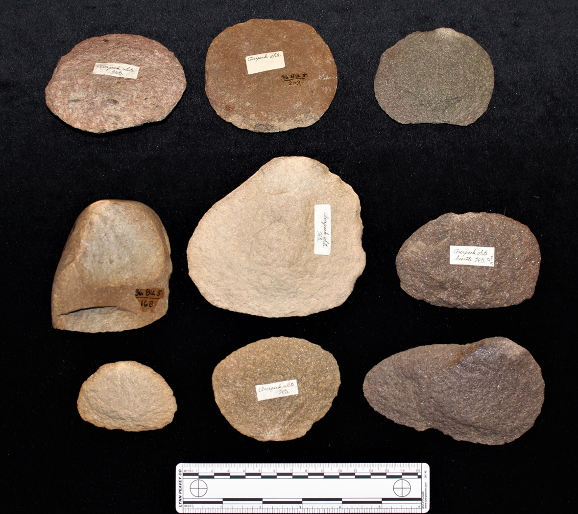
The
first formal recognition of the teshoa in Pennsylvania archaeology was John
Witthoft and the Forks of the Delaware Chapter 14, Society for Pennsylvania
Archaeology (SPA) investigations at the Overpeck site (36BU5) located near Kintnerville,
Bucks County, Pennsylvania.
Teshoas from Overpeck; middle row left
– teshoa pebble core. The State Museum of Pennsylvania.
The Early and Late Woodland soil strata at Overpeck contained teshoa tools and the cobble cores from which they were made along with the diagnostic artifacts such as pottery and projectile points that demonstrated clear cut cultural associations. Subsequently, teshoas and teshoa-like tools have been reported from other investigations at Pre-contact sites in the Delaware River valley and elsewhere.
Prior to the proposed construction of the Tocks Island Reservoir, archaeological excavations conducted by Herbert Kraft, Seton Hall University (1972), David Werner, Lenape Chapter 12, SPA, and Fred Kinsey, Franklin and Marshall College (1972) recovered teshoas and teshoa related tools from the Miller Field, Zimmermann, and Faucett sites, respectively. Other sites in the region continue to yield these unique tools in similar Delaware Valley contexts.
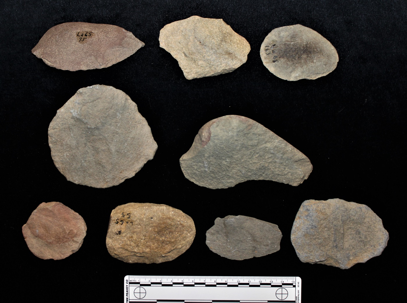
Stone tools that fit the teshoa description are also found on Archaic and Woodland age sites located in the Susquehanna Valley of central and southeastern Pennsylvania. One of these is the Parker Site (36Lu14), a Wyoming Valley Complex Late Woodland settlement dating to the 15th century C.E., located on the North Branch of the Susquehanna River. The site was investigated in the early 1970’s by Pennsylvania Historical and Museum Commission (PHMC) archaeologists (Herbstritt 2019; Smith 1973). Apart from a single teshoa core of granitic rock, all teshoa tools from Parker were made from indurated siltstone and sandstone cobbles.
 |
| Pebble core and teshoas from Parker. The State Museum of Pennsylvania. |
Archaeological excavations at a site near
Jersey Shore, Pennsylvania on the West Branch of the Susquehanna River, occupied
around the same time as 36Lu14, also recovered an assemblage of teshoa tools
manufactured from silt and sandstone cobbles.
 |
| Teshoas from Clinton County, Pennsylvania. West Branch Susquehanna River Valley. The State Museum of Pennsylvania. |
Teshoas
recovered from PHMC excavations at the deeply stratified Archaic site on Piney
Island, in the lower Susquehanna valley were made from a greater diversity of
stone material (Kent 1970). Locally sourced
quartzite and diabase cobbles were the preferred raw materials used to manufacture
teshoas and teshoa-like cobble tools at the Piney Island site. .
 |
| Teshoas from Piney Island. The State Museum of Pennsylvania. |
Experimental
archaeology research into teshoa tool use and function provides further
insights into the archaeological and ethnographic/linguistic record. Lithic
technology experimentation with replicated teshoa tools has assisted with interpreting
the potential functions of this class of artifact as it applies to stone tool use
in prehistory (Coles 1973; Roberts and Sant 1983). Comparing the distinct wear
patterns from cutting different materials such as wood, bone, skin, etc. on
experimentally replicated tools to the wear patterns on archaeologically recovered
teshoa tools can help identify and infer an artifact’s function or multiple
functions over its use-life.
 |
| Replicated examples of teshoa tools and pebble core. The State Museum of Pennsylvania. |
We
hope that you have enjoyed this blog on a unique, and often overlooked artifact
type in the archaeological site record. Please visit us next time for another topical
presentation from TWIPA.
References
Coles,
John
1973 Archaeology by Experiment. Charles
Scribner’s Sons. New York
Eyman,
Frances
1968 The Teshoa: A Shoshonean Woman’s Knife: A
Study of American Indian Chopper Industries. Pennsylvania Archaeologist
34(3-4):9-52.
Forks
of the Delaware Chapter 14
1980 The Overpeck Site (36BU5). Pennsylvania
Archaeologist 50(3):1-46.
Gatschet,
Albert S.
1888 Words of the Shoshone Language, as Spoken at
the Fort Hall Reservation in Idaho Territory, May 1888. MS, Archives of the
Bureau of American Ethnology, No. 749. Washington
Gebow,
Joseph A.
1868 A Vocabulary of the Snake or Sho-sho-nay Dialect.
2nd edition. Green River City. Wyoming.
Herbstritt,
James T.
2019 Becoming Susquehannock: The West Branch and
North Branch Traditions in: The Susquehannocks: New Perspectives on
Settlement and Cultural Identity. Edited by Paul A. Raber. The Pennsylvania
State University Press.
Kent, Barry C.
1970 Diffusion Spheres and Band Territoriality
Among the Archaic Period Cultures of the Northern Piedmont. Doctoral
dissertation. The Pennsylvania State University.
Kinsey, W.
Fred III
1972 Faucett Site 36-Pi-13A Archeology in the
Upper Delaware Valley: A Study of the Cultural Chronology of the Tocks Island
Reservoir. W. Fred Kinsey, III. Anthropological Series No. 2,
Pennsylvania Historical and Museum Commission. Harrisburg.
Kraft,
Herbert C.
1966 Teshoas and Elongated Pebble Tools. The
Archaeological Society of New Jersey. Bulletin Number 23: 1-6.
1972 The Miller Field Site; Warren County, New
Jersey in: Archeology in the Upper Delaware Valley: A
Study of the Cultural Chronology of the Tocks Island Reservoir. W. Fred Kinsey,
III. Anthropological Series No. 2, Pennsylvania Historical and Museum
Commission. Harrisburg.
Leslie,
Vernon
1973 Faces in Clay: The Archaeology and Early
History of the Red Man in the Upper Delaware Valley. 1st
Edition, T. Emmett Henderson, Publisher, Middletown, New York.
Leidy,
Joseph
1872 On Remains of Primitive Art in the Bridger
Basin of Southern Wyoming. In: A Geological and Geographical Survey of the
Territories, 6th Annual Report, edited by F.V. Heyden, pp.651-54.
Pls. 7-12. Washington
Roberts, Daniel G. and Mark B. Sant
1983 A
Preliminary Replicative Analysis of Teshoa Flake Production. Pennsylvania
Archaeologist 53(1-2):28-41.
Smith,
Ira F.
1973 The Parker Site; A Manifestation of the Wyoming
Valley Culture. Pennsylvania Archaeologist 43(3-4): 1-56
St.
Claire, Harry Hull, II
1902 Shoshonean Dictionary. MS, Archives of
the Bureau of American Ethnology, No. 2948A, pp.74-266. Washington.
Schmidt-Wartemberg,
H.
1889 Shoshone, Waskakie, Box Elder Creek, Utah.
(On Powell’s printed vocabulary Schedule sheets.) MS, Archives of the Bureau
of American Ethnology, No. 789. Washington.
Werner,
David
1972 Zimmerman Site 36-Pi-14 in: Archeology in
the Upper Delaware Valley: A Study of the Cultural Chronology of the Tocks
Island Reservoir. W. Fred Kinsey, III. Anthropological Series No. 2,
Pennsylvania Historical and Museum Commission. Harrisburg.
Witthoft,
John
n.d. Overpeck and Diehl Site Report. Unpublished
manuscript on file at the Section of Archaeology, The State Museum of
Pennsylvania.
For more information, visit
PAarchaeology.state.pa.us or the Hall of Anthropology and Archaeology at
The State Museum of Pennsylvania .